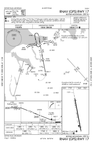
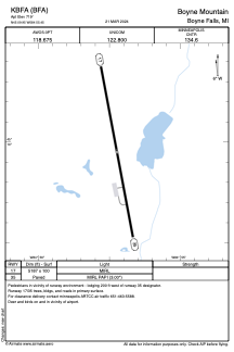


KBFA - Boyne Mountain
Located in Boyne Falls, United States
ICAO - BFA, IATA -
Data provided by AirmateGeneral information
Coordinates: N45°9'57" W84°55'27"
Elevation is 719 feet MSL.
Magnetic variation is -06° East View others Airports in Michigan
Operational data
Special qualification required
Current time UTC:
Current local time:
Weather at : KGLR - Gaylord Rgnl ( 24 km )
METAR: KGLR 081609Z AUTO 33004KT 8SM OVC006 09/09 A2968 RMK AO2 CIG 004V008 T00940089
Communications frequencies: [VIEW]
Runways:
| RWY identifier | QFU | Length (ft) | Width (ft) | Surface | LDA (ft) |
| 17 | 169° | 5187 | 100 | ASPH | |
| 35 | 349° | 5187 | 100 | ASPH |
Airport contact information
Address: Boyne Falls United States