


KBAB - Beale Afb
Located in Marysville, United States
ICAO - BAB, IATA - BAB
Data provided by AirmateGeneral information
Coordinates: N39°8'10" W121°26'12"
Elevation is 112 feet MSL.
Magnetic variation is 16° East View others Airports in California
Operational data
Special qualification required
Current time UTC:
Current local time:
Weather
METAR: KBAB 192255Z AUTO 11003KT 10SM CLR 28/12 A2986 RMK AO2 SLP114 T02750119 $
TAF: TAF AMD KBAB 192045Z 1920/2101 VRB06KT 9999 SKC QNH2984INS BECMG 2002/2003 14006KT 9999 FEW240 QNH2984INS BECMG 2017/2018 19006KT 9999 FEW200 QNH2996INS TX28/1923Z TN12/2013Z LAST NO AMDS AFT 1920 NEXT 2212
Communications frequencies: [VIEW]
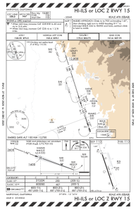
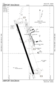
Runways:
| RWY identifier | QFU | Length (ft) | Width (ft) | Surface | LDA (ft) |
| 15 | 162° | 12001 | 300 | CONC | |
| 33 | 342° | 12001 | 300 | CONC |
Airport contact information
Address: Marysville United States
Other aviation service providers
Flight schools

Beale Aero Club & Flight Training Center
Beale Aero Club & Flight Training Center
christopher.cafaro@us.af.mil+1(530)634-9011