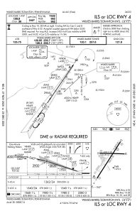
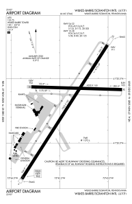


KAVP - Wilkes-Barre/Scranton Intl
Located in Wilkes-Barre/Scranton, United States
ICAO - AVP, IATA - AVP
Data provided by AirmateGeneral information
Coordinates: N41°20'18" W75°43'24"
Elevation is 961 feet MSL.
Magnetic variation is -11° East View others Airports in Pennsylvania
Operational data
Special qualification required
Current time UTC:
Current local time:
Weather
METAR: KAVP 190454Z AUTO 00000KT 10SM OVC015 08/04 A3010 RMK AO2 SLP195 T00830044 401280083
TAF: KAVP 182328Z 1900/1924 13005KT P6SM OVC025 FM190400 10004KT P6SM OVC015 FM191300 17008KT P6SM OVC025 FM191900 18007KT 6SM -RA OVC015
Communications frequencies: [VIEW]
Runways:
| RWY identifier | QFU | Length (ft) | Width (ft) | Surface | LDA (ft) |
| 04 | 33° | 7502 | 150 | ASPH | 7502 |
| 22 | 213° | 7502 | 150 | ASPH | 7502 |
| 10 | 92° | 4300 | 150 | ASPH | 4300 |
| 28 | 272° | 4300 | 150 | ASPH | 4300 |
Airport contact information
Address: Wilkes-Barre/Scranton United States
Other aviation service providers
Flight schools

Aviation Technologies, Inc.
Aviation Technologies, Inc.
cphebus@aviation-technologies.com+1(570)457-4485