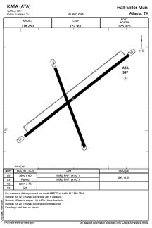


KATA - Hall-Miller Muni
Located in Atlanta, United States
ICAO - ATA, IATA -
Data provided by AirmateGeneral information
Coordinates: N33°6'9" W94°11'42"
Elevation is 280 feet MSL.
Magnetic variation is 04° East View others Airports in Texas
Operational data
Special qualification required
Current time UTC:
Current local time:
Weather at : KTXK - Texarkana Rgnl-Webb Fld ( 43 km )
METAR: KTXK 141420Z 30007KT 10SM SCT008 22/17 A2975 RMK AO2 T02220172
TAF: KTXK 141403Z 1414/1512 25005KT P6SM OVC005 TEMPO 1414/1415 SCT005 FM141500 28007KT P6SM SCT025 FM141700 29010G15KT P6SM FEW035 FM150300 VRB05KT P6SM SKC FM150900 VRB03KT 4SM BR SKC
Communications frequencies: [VIEW]
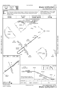
Runways:
| RWY identifier | QFU | Length (ft) | Width (ft) | Surface | LDA (ft) |
| 05 | 52° | 3800 | 60 | ASPH | |
| 23 | 232° | 3800 | 60 | ASPH | |
| 15 | 160° | 2264 | 75 | GRASS | |
| 33 | 340° | 2264 | 75 | GRASS |
Airport contact information
Address: Atlanta United States