


KASD - Slidell
Located in Slidell, United States
ICAO - ASD, IATA -
Data provided by AirmateGeneral information
Coordinates: N30°20'47" W89°49'15"
Elevation is 28 feet MSL.
Magnetic variation is 02° East View others Airports in Louisiana
Operational data
Special qualification required
Current time UTC:
Current local time:
Weather
METAR: KASD 272053Z AUTO 14013G25KT 10SM -RA BKN028 BKN034 28/20 A3008 RMK AO2 PK WND 13027/2037 SLP185 P0000 60000 T02780200 56011
TAF: KASD 271737Z 2718/2818 13014G28KT P6SM BKN027 BKN035 FM280700 11011KT P6SM BKN020 FM281300 14015G25KT P6SM BKN015
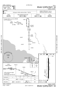
Communications frequencies: [VIEW]
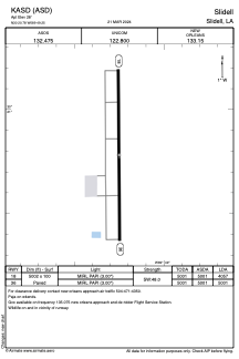
Runways:
| RWY identifier | QFU | Length (ft) | Width (ft) | Surface | LDA (ft) |
| 18 | 180° | 5002 | 100 | ASPH | 4057 |
| 36 | 360° | 5002 | 100 | ASPH | 5001 |
Airport contact information
Address: Slidell United States