


KART - Watertown Intl
Located in Watertown, United States
ICAO - ART, IATA - ART
Data provided by AirmateGeneral information
Coordinates: N43°59'31" W76°1'10"
Elevation is 330 feet MSL.
Magnetic variation is -12° East View others Airports in New York
Operational data
Special qualification required
Current time UTC:
Current local time:
Weather
TAF: KART 052336Z 0600/0624 19005KT P6SM OVC020 FM060500 20007KT 6SM BR OVC007 FM060700 24005KT 1SM BR OVC005 FM061200 25005KT 3SM BR BKN008 FM061500 25007KT P6SM BKN025 FM061800 25008KT P6SM SCT040
Communications frequencies: [VIEW]
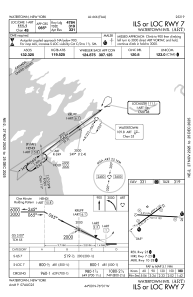
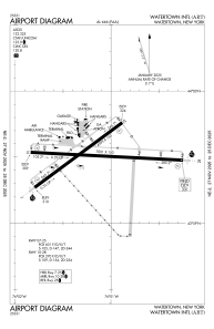
Runways:
| RWY identifier | QFU | Length (ft) | Width (ft) | Surface | LDA (ft) |
| 07 | 53° | 4999 | 150 | ASPH | 4784 |
| 25 | 233° | 4999 | 150 | ASPH | 4999 |
| 10 | 93° | 7001 | 150 | ASPH | 7001 |
| 28 | 273° | 7001 | 150 | ASPH | 7001 |
Airport contact information
Address: Watertown United States
