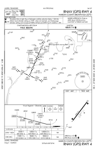
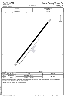


KAPT - Marion County/Brown Fld
Located in Jasper, United States
ICAO - APT, IATA - APT
Data provided by AirmateGeneral information
Coordinates: N35°3'38" W85°35'7"
Elevation is 641 feet MSL.
Magnetic variation is -02° East View others Airports in Tennessee
Operational data
Special qualification required
Current time UTC:
Current local time:
Weather at : KCHA - Lovell Fld ( 35 km )
METAR: KCHA 130653Z 00000KT 10SM CLR 17/14 A2997 RMK AO2 SLP142 T01670139
TAF: KCHA 130544Z 1306/1406 VRB04KT P6SM SCT150 BKN250 FM131400 16005KT P6SM VCSH BKN050 FM131700 17008G15KT P6SM BKN035 PROB30 1321/1402 4SM SHRA BKN025 FM140200 14005KT 6SM BR VCSH OVC015
Communications frequencies: [VIEW]
Runways:
| RWY identifier | QFU | Length (ft) | Width (ft) | Surface | LDA (ft) |
| 04 | 38° | 3498 | 75 | ASPH | |
| 22 | 218° | 3498 | 75 | ASPH |
Airport contact information
Address: Jasper United States