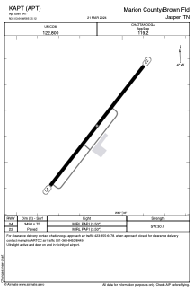


KAPT - Marion County/Brown Fld
Located in Jasper, United States
ICAO - APT, IATA - APT
Data provided by AirmateGeneral information
Coordinates: N35°3'38" W85°35'7"
Elevation is 641 feet MSL.
Magnetic variation is -02° East View others Airports in Tennessee
Operational data
Special qualification required
Current time UTC:
Current local time:
Weather at : KCHA - Lovell Fld ( 35 km )
METAR: KCHA 041253Z 19005KT 6SM -RA BR FEW010 BKN035 OVC055 20/18 A3005 RMK AO2 SLP171 P0002 T02000183
TAF: KCHA 041120Z 0412/0512 18005KT 6SM -SHRA VCTS BKN025CB FM041600 20006KT P6SM VCTS BKN035CB TEMPO 0418/0422 4SM TSRA BR BKN025CB FM050100 17003KT P6SM VCSH BKN035
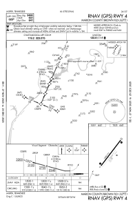
Communications frequencies: [VIEW]
Runways:
| RWY identifier | QFU | Length (ft) | Width (ft) | Surface | LDA (ft) |
| 04 | 38° | 3498 | 75 | ASPH | |
| 22 | 218° | 3498 | 75 | ASPH |
Airport contact information
Address: Jasper United States