


KALW - Walla Walla Rgnl
Located in Walla Walla, United States
ICAO - ALW, IATA - ALW
Data provided by AirmateGeneral information
Coordinates: N46°5'33" W118°17'3"
Elevation is 1194 feet MSL.
Magnetic variation is 14° East View others Airports in Washington
Operational data
Special qualification required
Current time UTC:
Current local time:
Weather
METAR: KALW 292053Z 21023G29KT 10SM CLR 12/M01 A2996 RMK AO2 PK WND 21029/2053 SLP148 60000 T01221011 58005
TAF: KALW 291739Z 2918/3018 22015G24KT P6SM -SHRA OVC050 TEMPO 2918/2921 22015G24KT -SHRA OVC040 FM300300 20012KT P6SM BKN070
Communications frequencies: [VIEW]
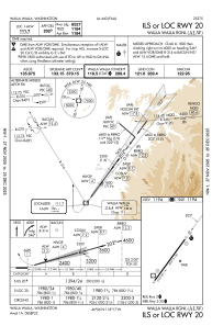
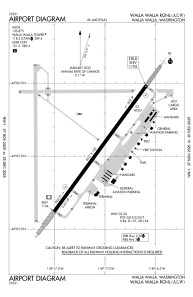
Runways:
| RWY identifier | QFU | Length (ft) | Width (ft) | Surface | LDA (ft) |
| 02 | 36° | 6527 | 150 | CONC | 6527 |
| 20 | 216° | 6527 | 150 | CONC | 6527 |
Airport contact information
Address: Walla Walla United States
