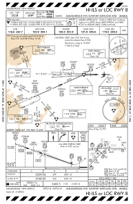
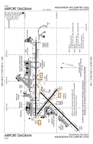


KABQ - Albuquerque Intl Sunport
Located in Albuquerque, United States
ICAO - ABQ, IATA - ABQ
Data provided by AirmateGeneral information
Coordinates: N35°2'20" W106°36'30"
Elevation is 5354 feet MSL.
Magnetic variation is 11° East View others Airports in New Mexico
Operational data
Special qualification required
Current time UTC:
Current local time:
Weather
METAR: KABQ 270952Z 29011KT 10SM SCT040 BKN065 OVC100 10/M02 A2982 RMK AO2 SLP041 MTNS OBSC NE AND SE SHRA DSNT N-E-SE T01001017
TAF: KABQ 270806Z 2708/2806 24009KT P6SM SCT100 BKN200 TEMPO 2708/2710 30012G22KT FM271700 22012G18KT P6SM SCT050 BKN120 FM272000 25014G26KT P6SM VCSH BKN070 FM280100 33009KT P6SM BKN060
Communications frequencies: [VIEW]
Runways:
| RWY identifier | QFU | Length (ft) | Width (ft) | Surface | LDA (ft) |
| 03 | 45° | 10000 | 150 | CONC | 10000 |
| 21 | 225° | 10000 | 150 | CONC | 10000 |
| 08 | 90° | 13793 | 150 | CONC | 12793 |
| 26 | 270° | 13793 | 150 | CONC | 13793 |
| 12 | 129° | 6000 | 150 | CONC | 6000 |
| 30 | 309° | 6000 | 150 | CONC | 6000 |
Airport contact information
Address: Albuquerque United States
Other aviation service providers
Flight schools

Vertical Limit Aviation, Llc
Vertical Limit Aviation, Llc
dchristian@enchantmenthelicopters.com+1(505)831-4354