


K75 - Osborne Muni
Located in Osborne, United States
ICAO - K75, IATA -
Data provided by AirmateGeneral information
Coordinates: N39°25'60" W98°40'48"
Elevation is 1547 feet MSL.
Magnetic variation is 08° East View others Airports in Kansas
Operational data
Special qualification required
Current time UTC:
Current local time:
Weather at : KRSL - Russell Muni ( 63 km )
METAR: KRSL 221153Z AUTO 10SM OVC110 11/11 A2999 RMK AO2 SLP150 60041 70042 T01110106 10139 20111 53006
TAF: KRSL 221122Z 2212/2312 29006KT P6SM SCT100 FM221600 VRB04KT P6SM SKC FM222000 14009KT P6SM SKC
Communications frequencies: [VIEW]
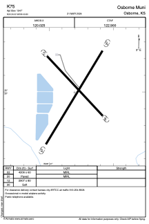
Runways:
| RWY identifier | QFU | Length (ft) | Width (ft) | Surface | LDA (ft) |
| 02 | 0° | 4206 | 60 | ASPH | |
| 20 | 0° | 4206 | 60 | ASPH | |
| 12 | 0° | 2907 | 80 | GRASS | |
| 30 | 0° | 2907 | 80 | GRASS |
Airport contact information
Address: Osborne United States