


IN29 - Durflinger
Located in Otterbein, United States
ICAO - IN29, IATA -
Data provided by AirmateGeneral information
Coordinates: N40°34'26" W87°6'12"
Elevation is 748 feet MSL.
Magnetic variation is -02° East View others Airports in Indiana
Operational data
Special qualification required
Current time UTC:
Current local time:
Weather at : KLAF - Purdue University ( 23 km )
METAR: KLAF 141354Z 14005KT 10SM BKN080 18/14 A2979 RMK AO2 SLP083 T01830144
TAF: KLAF 141120Z 1412/1512 12003KT P6SM BKN025 FM141800 12006KT P6SM -SHRA OVC015 FM142200 12007KT 6SM -SHRA VCTS OVC021CB FM150200 07005KT 6SM -SHRA BR BKN017 FM150500 02008KT P6SM VCSH BKN009 FM151100 11006KT P6SM OVC025
Communications frequencies: [VIEW]
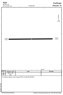
Runways:
| RWY identifier | QFU | Length (ft) | Width (ft) | Surface | LDA (ft) |
| 09 | 90° | 3600 | 132 | GRASS | |
| 27 | 270° | 3600 | 132 | GRASS |
Airport contact information
Address: Otterbein United States