


ID57 - Red Bird
Located in Lewiston, United States
ICAO - ID57, IATA -
Data provided by AirmateGeneral information
Coordinates: N46°13'23" W116°52'12"
Elevation is 2996 feet MSL.
View others Airports in Idaho
Operational data
Special qualification required
Current time UTC:
Current local time:
Weather at : KLWS - Lewiston/Nez Perce County ( 20 km )
METAR: KLWS 210856Z AUTO 07009KT 10SM CLR 11/04 A3005 RMK AO2 SLP173 T01060044 51002
TAF: KLWS 210520Z 2106/2206 20004KT P6SM SCT100 FM210700 20005KT P6SM FEW100 FM211300 VRB04KT P6SM BKN200 FM212000 31008KT P6SM SCT060 BKN150 FM220300 25007KT 6SM -RA OVC040
Communications frequencies: [VIEW]
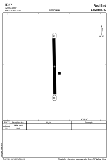
Runways:
| RWY identifier | QFU | Length (ft) | Width (ft) | Surface | LDA (ft) |
| 17 | 0° | 1484 | 65 | GRASS | |
| 35 | 0° | 1484 | 65 | GRASS |
Airport contact information
Address: Lewiston United States