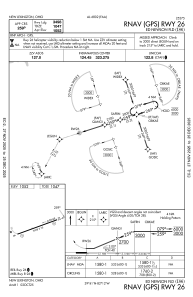
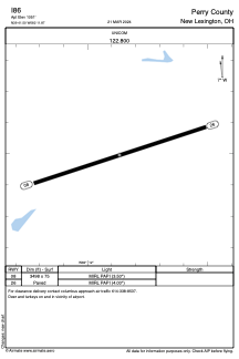


I86 - Perry County
Located in New Lexington, United States
ICAO - I86, IATA -
Data provided by AirmateGeneral information
Coordinates: N39°41'30" W82°11'52"
Elevation is 1051 feet MSL.
Magnetic variation is -07° East View others Airports in Ohio
Operational data
Special qualification required
Current time UTC:
Current local time:
Weather at : KZZV - Zanesville Muni ( 38 km )
METAR: KZZV 210453Z AUTO 00000KT 10SM CLR 19/17 A2995 RMK AO2 SLP136 T01940167 403060139
TAF: KZZV 202320Z 2100/2124 VRB05KT P6SM FEW250 FM211600 23009KT P6SM FEW060
Communications frequencies: [VIEW]
Runways:
| RWY identifier | QFU | Length (ft) | Width (ft) | Surface | LDA (ft) |
| 08 | 72° | 3498 | 75 | ASPH | |
| 26 | 252° | 3498 | 75 | ASPH |
Airport contact information
Address: New Lexington United States