


I71 - Morgan County
Located in Mc Connelsville, United States
ICAO - I71, IATA -
Data provided by AirmateGeneral information
Coordinates: N39°39'15" W81°48'11"
Elevation is 1000 feet MSL.
Magnetic variation is -06° East View others Airports in Ohio
Operational data
Special qualification required
Current time UTC:
Current local time:
Weather at : KZZV - Zanesville Muni ( 33 km )
METAR: KZZV 171253Z AUTO 15004KT 5SM BR FEW006 BKN047 BKN060 18/17 A2987 RMK AO2 RAE14 SLP112 P0000 T01780167
TAF: KZZV 171140Z 1712/1812 20004KT 5SM -SHRA BKN040 TEMPO 1713/1716 4SM SHRA BKN025 FM171600 23007KT P6SM VCSH OVC040 PROB30 1718/1722 4SM -TSRA BKN030CB FM180300 18003KT 6SM BR BKN025 FM180900 18003KT 4SM BR BKN008
Communications frequencies: [VIEW]
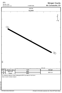
Runways:
| RWY identifier | QFU | Length (ft) | Width (ft) | Surface | LDA (ft) |
| 12 | 119° | 3500 | 65 | ASPH | |
| 30 | 299° | 3500 | 65 | ASPH |
Airport contact information
Address: Mc Connelsville United States