


I44 - Dahio Trotwood
Located in Dayton, United States
ICAO - I44, IATA -
Data provided by AirmateGeneral information
Coordinates: N39°45'54" W84°20'35"
Elevation is 925 feet MSL.
Magnetic variation is -04° East View others Airports in Ohio
Operational data
Special qualification required
Current time UTC:
Current local time:
Weather at : KDAY - James M Cox Dayton Intl ( 19 km )
METAR: KDAY 162356Z 18004KT 10SM BKN095 BKN140 24/13 A2981 RMK AO2 SLP089 T02390133 10267 20233 58016 $
TAF: KDAY 162346Z 1700/1724 21004KT P6SM BKN140 FM170900 21005KT P6SM -SHRA VCTS OVC040CB FM171300 23007KT P6SM VCSH BKN023 FM171700 24008KT P6SM VCSH OVC035
Communications frequencies: [VIEW]
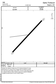
Runways:
| RWY identifier | QFU | Length (ft) | Width (ft) | Surface | LDA (ft) |
| 04 | 43° | 2900 | 52 | ASPH | |
| 22 | 223° | 2900 | 52 | ASPH |
Airport contact information
Address: Dayton United States