


I20 - Ed-Air
Located in Oaktown, United States
ICAO - I20, IATA -
Data provided by AirmateGeneral information
Coordinates: N38°51'5" W87°29'59"
Elevation is 426 feet MSL.
Magnetic variation is -01° East View others Airports in Indiana
Operational data
Special qualification required
Current time UTC:
Current local time:
Weather at : KLWV - Lawrenceville-Vincennes Intl ( 13 km )
METAR: KLWV 212153Z AUTO 19021G30KT 10SM FEW055 32/18 A2977 RMK AO2 PK WND 20030/2145 SLP078 T03170178
Communications frequencies: [VIEW]
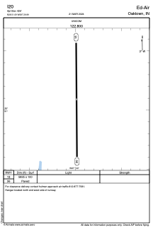
Runways:
| RWY identifier | QFU | Length (ft) | Width (ft) | Surface | LDA (ft) |
| 18 | 0° | 5835 | 100 | ASPH | |
| 36 | 0° | 5835 | 100 | ASPH |
Airport contact information
Address: Oaktown United States