


HKNW - Nairobi Wilson
Located in Nairobi, Kenya
ICAO - HKNW, IATA - WIL
Data provided by AirmateGeneral information
Coordinates: S1°19'17" E36°48'54"
Elevation is 5546 feet MSL.
Magnetic variation is 1° East View others Airports in Nairobi Province
Operational data
Special qualification required
Current time UTC:
Current local time:
Communications frequencies: [VIEW]
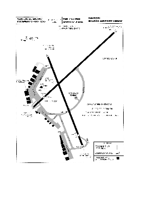
Runways:
| RWY identifier | QFU | Length (ft) | Width (ft) | Surface | LDA (ft) |
| 14 | 135° | 4432 | 73 | ASPH | 4462 |
| 32 | 315° | 4432 | 73 | ASPH | 5098 |
| 07 | 71° | 4747 | 69 | ASPH | 4790 |
| 25 | 251° | 4747 | 69 | ASPH | 5098 |
Airport contact information
Address: Nairobi Kenya