


F87 - Union Parish
Located in Farmerville, United States
ICAO - F87, IATA -
Data provided by AirmateGeneral information
Coordinates: N32°43'30" W92°20'14"
Elevation is 121 feet MSL.
Magnetic variation is 05° East View others Airports in Louisiana
Operational data
Special qualification required
Current time UTC:
Current local time:
Weather at : KRSN - Ruston Rgnl ( 33 km )
METAR: KRSN 281215Z AUTO 13003KT 10SM BKN013 20/19 A2997 RMK AO2 RAB1151E1206 P0000 T01980193 $
Communications frequencies: [VIEW]
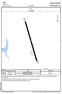
Runways:
| RWY identifier | QFU | Length (ft) | Width (ft) | Surface | LDA (ft) |
| 16 | 163° | 3003 | 75 | ASPH | |
| 34 | 343° | 3003 | 75 | ASPH |
Airport contact information
Address: Farmerville United States