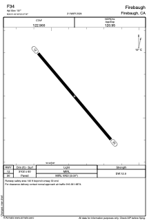


F34 - Firebaugh
Located in Firebaugh, United States
ICAO - F34, IATA -
Data provided by AirmateGeneral information
Coordinates: N36°51'36" W120°27'52"
Elevation is 157 feet MSL.
Magnetic variation is 16° East View others Airports in California
Operational data
Special qualification required
Current time UTC:
Current local time:
Weather at : KMAE - Madera Muni ( 34 km )
METAR: KMAE 201153Z AUTO 00000KT 9SM CLR 12/10 A2996 RMK AO2 SLP142 T01170100 10161 20117 53007
Communications frequencies: [VIEW]
Runways:
| RWY identifier | QFU | Length (ft) | Width (ft) | Surface | LDA (ft) |
| 12 | 140° | 3102 | 60 | ASPH | |
| 30 | 320° | 3102 | 60 | ASPH |
Airport contact information
Address: Firebaugh United States