


ESTL - Ljungbyhed
Located in Ljungbyhed, Sweden
ICAO - ESTL, IATA -
Data provided by AirmateGeneral information
Coordinates: N56°5'7" E13°12'25"
Elevation is 139 feet MSL.
Magnetic variation is +4.0° East View others Airports in Skåne län
Operational data
Special qualification required
Current time UTC:
Current local time:
Weather at : ESMS - Malmo ( 60 km )
METAR: ESMS 101350Z 30007KT 9999 SCT019 BKN025 14/10 Q1022
TAF: TAF AMD ESMS 101215Z 1012/1112 30008KT 9999 BKN008 TEMPO 1012/1014 BKN012 BECMG 1014/1016 SCT020 TEMPO 1022/1104 3000 BR BKN012 TEMPO 1104/1110 2000 BR -DZ BKN008 BECMG 1110/1112 12010KT
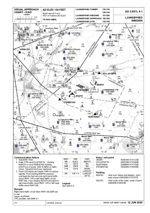
Communications frequencies: [VIEW]
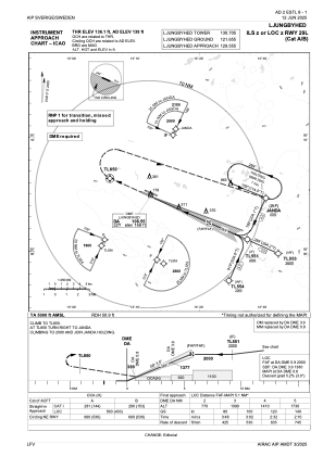
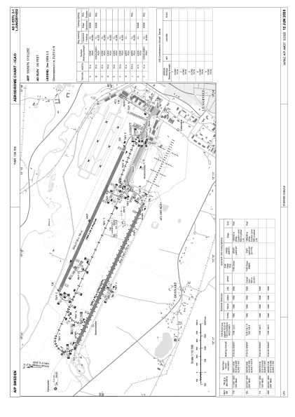
Runways:
| RWY identifier | QFU | Length (ft) | Width (ft) | Surface | LDA (ft) |
| 11R | 114° | 6516 | 131 | CONC+ASPH | 6516 |
| 29L | 294° | 6516 | 131 | CONC+ASPH | 6516 |
| 11L | 113° | 6555 | 131 | ASPH | 6555 |
| 29R | 293° | 6555 | 131 | ASPH | 6555 |
Airport contact information
Address: Ljungbyhed Sweden
Other aviation service providers
Aviation club (not for profit)

Lunds Universitet Trafikflyghögskolan
Lunds Universitet Trafikflyghögskolan
thomas.hallstrom@tfhs.lu.se+46435445400