


EHST - Stadskanaal
Located in Stadskanaal, Netherlands
ICAO - EHST, IATA -
Data provided by AirmateGeneral information
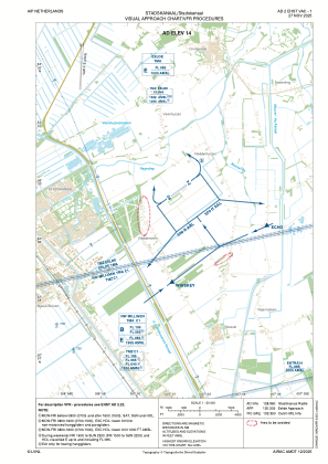
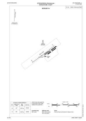
Coordinates: N52°59'55" E7°1'22"
Elevation is 14 feet MSL.
Magnetic variation is 2.2238° East View others Airports in Groningen
Operational data
Special qualification required
Current time UTC:
Current local time:
Weather at : EHGG - Groningen/Eelde ( 33 km )
TAF: TAF EHGG 221654Z 2218/2324 20007KT 9999 FEW030 PROB40 2305/2309 BKN014 BECMG 2310/2313 23010KT BECMG 2318/2321 VRB02KT PROB30 2321/2324 4000 BR
Communications frequencies: [VIEW]
Runways:
| RWY identifier | QFU | Length (ft) | Width (ft) | Surface | LDA (ft) |
| 06 | 60° | 1640 | 98 | GRASS | |
| 24 | 240° | 1640 | 98 | GRASS |
Airport contact information
Address: Stadskanaal Netherlands
