


EGYD - Cranwell
Located in Sleaford, United Kingdom
ICAO - EGYD, IATA -
Data provided by AirmateGeneral information
Coordinates: N53°1'47" W0°29'34"
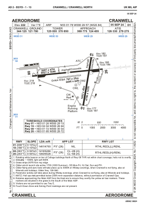
Elevation is 222 feet MSL.
Magnetic variation is 0° East View others Airports in England
Operational data
Special qualification required
Current time UTC:
Current local time:
Weather
METAR: EGYD 300820Z 16014KT CAVOK 13/08 Q1012 NOSIG RMK BLU BLU
TAF: TAF AMD EGYD 300750Z 3009/3018 16016G26KT 9999 FEW040 BECMG 3015/3018 14012KT
Communications frequencies: [VIEW]
Runways:
| RWY identifier | QFU | Length (ft) | Width (ft) | Surface | LDA (ft) |
| 01 | 8° | 4797 | 148 | ASPH | 4797 |
| 19 | 188° | 4797 | 148 | ASPH | 4797 |
| 08 | 83° | 6831 | 148 | ASPH | 6286 |
| 26 | 263° | 6831 | 148 | ASPH | 6532 |
| 08R | 0° | 0 | 0 | UNK | |
| 26L | 0° | 0 | 0 | UNK | |
| 08N | 83° | 2497 | 82 | GRAS | 2497 |
| 26N | 263° | 2497 | 82 | GRAS | 2497 |
| 03 | 0° | 3622 | 98 | UNK | |
| 06 | 0° | 3930 | 98 | UNK | |
| 21 | 0° | 3622 | 98 | UNK | |
| 24 | 0° | 3930 | 98 | UNK |
Airport contact information
Address: Sleaford United Kingdom