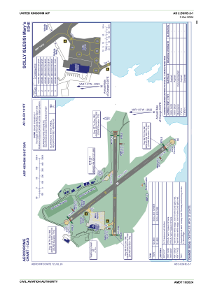


EGHE - Scilly Isles/St Mary's
Located in Hugh Town, United Kingdom
ICAO - EGHE, IATA - ISC
Data provided by AirmateGeneral information
Coordinates: N49°54'48" W6°17'30"
Elevation is 121 feet MSL.
View others Airports in England
Operational data
Special qualification required
Current time UTC:
Current local time:
Weather
METAR: EGHE 061250Z 34014KT 9999 FEW010 15/11 Q1011
TAF: TAF EGHE 061055Z 0612/0618 01012KT 9999 SCT035 TEMPO 0612/0618 BKN012
Communications frequencies: [VIEW]
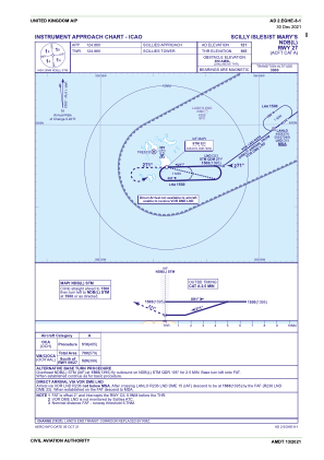
Runways:
| RWY identifier | QFU | Length (ft) | Width (ft) | Surface | LDA (ft) |
| 14 | 139° | 2123 | 75 | asphalt | |
| 32 | 319° | 2123 | 75 | asphalt | |
| 09 | 87° | 1713 | 59 | Grass/Asphalt | |
| 27 | 267° | 1713 | 59 | Grass/Asphalt |
Airport contact information
Address: Hugh Town United Kingdom