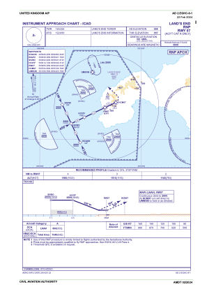
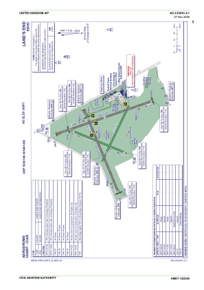


EGHC - Land's End
Located in Penzance, United Kingdom
ICAO - EGHC, IATA - LEQ
Data provided by AirmateGeneral information
Coordinates: N50°6'10" W5°40'14"
Elevation is 398 feet MSL.
View others Airports in England
Operational data
Special qualification required
Current time UTC:
Current local time:
Weather
METAR: EGHC 291120Z 20026KT 9000 -RA FEW006 SCT020 10/09 Q1009
TAF: TAF EGHC 291057Z 2912/2918 20020G35KT 9999 FEW010 SCT020 BECMG 2912/2915 23014KT TEMPO 2912/2914 8000 -RA BKN010 PROB30 TEMPO 2912/2914 4000 RA BKN004 PROB40 TEMPO 2914/2918 8000 -RA BKN010
Communications frequencies: [VIEW]
Runways:
| RWY identifier | QFU | Length (ft) | Width (ft) | Surface | LDA (ft) |
| 02 | 20° | 1585 | 62 | Grass | |
| 20 | 200° | 1585 | 62 | Grass | |
| 07 | 65° | 2274 | 59 | Grass | |
| 25 | 245° | 2274 | 59 | Grass | |
| 16 | 158° | 2572 | 59 | Grass | |
| 34 | 338° | 2572 | 59 | Grass | |
| 11 | 113° | 1568 | 59 | UNK | |
| 29 | 293° | 1568 | 59 | UNK |
Airport contact information
Address: Penzance United Kingdom