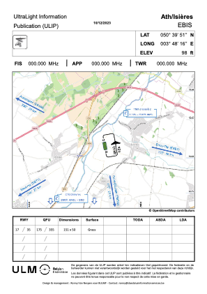


EBIS - Ath / Isieres
Located in Ath, Belgium
ICAO - EBIS, IATA -
Data provided by AirmateGeneral information
Coordinates: N50°39'51" E3°48'16"
Elevation is 90 feet MSL.
Magnetic variation is 1° East View others Airports in Hainaut
Operational data
Special qualification required
Current time UTC:
Current local time:
Weather at : EBCV - Chievres ( 10 km )
METAR: EBCV 181625Z AUTO 27004KT 9999 FEW020/// SCT037/// BKN085/// 18/14 Q1011 BLU
TAF: TAF EBCV 181541Z 1819/1907 28005KT 9999 FEW020 SCT025 TEMPO 1819/1822 4000 SHRA SCT017TCU BKN020 PROB30 TEMPO 1819/1822 30010KT 2500 -TSRA BKN015CB BECMG 1900/1902 VRB03KT 3000 BR SCT005 TEMPO 1902/1907 500 FG BKN001 BY EBWM
Communications frequencies: [VIEW]
Runways:
| RWY identifier | QFU | Length (ft) | Width (ft) | Surface | LDA (ft) |
| 17 | 0° | 495 | 164 | GRASS | |
| 35 | 0° | 495 | 164 | GRASS |
Airport contact information
Address: Ath Belgium