


E89 - Conchas Lake
Located in Conchas Dam, United States
ICAO - E89, IATA -
Data provided by AirmateGeneral information
Coordinates: N35°22'4" W104°10'50"
Elevation is 4232 feet MSL.
Magnetic variation is 10° East View others Airports in New Mexico
Operational data
Special qualification required
Current time UTC:
Current local time:
Weather at : KTCC - Tucumcari Muni ( 56 km )
METAR: KTCC 220253Z AUTO 27004KT 10SM CLR 19/M04 A2980 RMK AO2 SLP041 T01891039 53010
TAF: KTCC 212352Z 2200/2224 27022G34KT P6SM SKC FM220200 25009KT P6SM FEW150 FM220700 03020G32KT P6SM SCT120 FM221300 06010KT P6SM FEW025 FM222000 13011KT P6SM SKC
Communications frequencies: [VIEW]
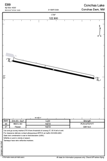
Runways:
| RWY identifier | QFU | Length (ft) | Width (ft) | Surface | LDA (ft) |
| 09 | 0° | 4800 | 60 | ASPH | |
| 27 | 0° | 4800 | 60 | ASPH |
Airport contact information
Address: Conchas Dam United States