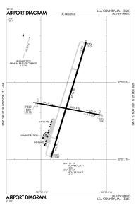


E26 - Lea County/Jal
Located in Jal, United States
ICAO - E26, IATA -
Data provided by AirmateGeneral information
Coordinates: N32°7'52" W103°9'17"
Elevation is 3118 feet MSL.
Magnetic variation is 09° East View others Airports in New Mexico
Operational data
Special qualification required
Current time UTC:
Current local time:
Weather at : KINK - Winkler County ( 39 km )
METAR: KINK 051200Z AUTO 09006KT 10SM OVC009 17/15 A2994 RMK AO2 T01670150
TAF: KINK 051120Z 0512/0612 05008KT P6SM OVC015 FM051800 12008KT P6SM BKN030 FM052000 15009KT P6SM FEW060 FM060100 13014G22KT P6SM SCT150
Communications frequencies: [VIEW]
Runways:
| RWY identifier | QFU | Length (ft) | Width (ft) | Surface | LDA (ft) |
| 01 | 17° | 4704 | 60 | ASPH | |
| 19 | 197° | 4704 | 60 | ASPH | |
| 09 | 101° | 2604 | 50 | ASPH | |
| 27 | 281° | 2604 | 50 | ASPH |
Airport contact information
Address: Jal United States