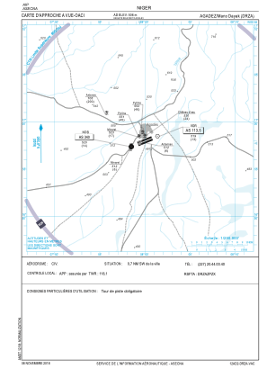
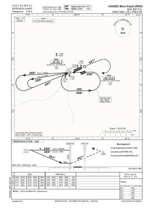


DRZA - Agadez/Mano Dayak
Located in Agadez, Niger
ICAO - DRZA, IATA - AJY
Data provided by AirmateGeneral information
Coordinates: N16°57'44" E7°59'25"
Elevation is 1660 feet MSL.
View others Airports in Agadez Region
Operational data
Special qualification required
Current time UTC:
Current local time:
Weather
TAF: TAF DRZA 172300Z 1800/1824 10012KT 4000 DU NSC BECMG 1802/1804 6000 NSW TEMPO 1807/1813 14022KT 3500 BLDU
Communications frequencies: [VIEW]
Runways:
| RWY identifier | QFU | Length (ft) | Width (ft) | Surface | LDA (ft) |
| 07L | 68° | 9843 | 98 | UNK | |
| 25R | 248° | 9843 | 98 | UNK | |
| 07R | 68° | 6791 | 98 | UNK | |
| 25L | 248° | 6791 | 98 | UNK |
Airport contact information
Address: Agadez Niger