


D69 - Rogersburg
Located in Anatone, United States
ICAO - D69, IATA -
Data provided by AirmateGeneral information
Coordinates: N46°4'27" W116°57'54"
Elevation is 869 feet MSL.
View others Airports in Washington
Operational data
Special qualification required
Current time UTC:
Current local time:
Weather at : KLWS - Lewiston/Nez Perce County ( 34 km )
METAR: KLWS 211756Z 02005KT 10SM CLR 18/04 A3002 RMK AO2 SLP163 T01780044 10178 20067 58019
TAF: KLWS 211744Z 2118/2218 VRB04KT P6SM BKN250 FM212200 29008KT P6SM BKN080 OVC180 FM220300 29008KT 6SM -RA BR OVC035 FM220500 20007KT 5SM -RA BR OVC025 FM221100 26008KT 6SM BR BKN025 OVC050 FM221500 30013G22KT P6SM BKN045
Communications frequencies: [VIEW]
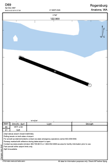
Runways:
| RWY identifier | QFU | Length (ft) | Width (ft) | Surface | LDA (ft) |
| 09 | 112° | 1471 | 50 | GRASS | |
| 27 | 292° | 1471 | 50 | GRASS |
Airport contact information
Address: Anatone United States