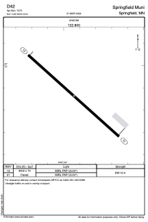


D42 - Springfield Muni
Located in Springfield, United States
ICAO - D42, IATA -
Data provided by AirmateGeneral information
Coordinates: N44°13'52" W94°59'56"
Elevation is 1073 feet MSL.
Magnetic variation is 02° East View others Airports in Minnesota
Operational data
Special qualification required
Current time UTC:
Current local time:
Weather at : KRWF - Redwood Falls Muni ( 36 km )
METAR: KRWF 070153Z AUTO 11016G30KT 10SM CLR 21/09 A2950 RMK AO2 PK WND 12035/0057 SLP985 T02060094
TAF: KRWF 062331Z 0700/0724 13022G32KT P6SM BKN050 FM070300 14020G30KT 6SM -RA BR OVC035 TEMPO 0703/0707 2SM TSRA BR BKN025CB FM070700 14017G26KT 5SM -RA BR OVC040 FM071300 17012G19KT P6SM BKN050 FM072300 21014KT P6SM OVC100
Communications frequencies: [VIEW]
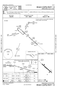
Runways:
| RWY identifier | QFU | Length (ft) | Width (ft) | Surface | LDA (ft) |
| 13 | 132° | 3402 | 75 | ASPH | |
| 31 | 312° | 3402 | 75 | ASPH |
Airport contact information
Address: Springfield United States