


CZBD - Ilford
Located in , Canada
ICAO - CZBD, IATA - ILF
Data provided by AirmateGeneral information
Coordinates: N56°3'6" W95°37'5"
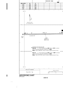
Elevation is 643 feet MSL.
Magnetic variation is 0.5108° East View others Airports in Manitoba
Operational data
Special qualification required
Current time UTC:
Current local time:
Weather at : CYGX - Gillam ( 66 km )
METAR: CYGX 162000Z 14006G15KT 100V180 15SM BKN024 BKN090 19/02 A2973 RMK SC5AC2 SLP074 DENSITY ALT 1300FT
TAF: TAF CYGX 161840Z 1619/1707 14010KT P6SM BKN090 FM162000 13010G20KT P6SM SCT020 BKN040 TEMPO 1620/1701 5SM -SHRA BR BKN020 OVC040 FM170100 12006KT 6SM -SHRA BR OVC025 TEMPO 1701/1707 4SM -SHRA BR SCT008 OVC020 RMK FCST BASED ON OBS BY OTHER SRCS. NXT FCST BY 170100Z
Communications frequencies: [VIEW]
Runways:
| RWY identifier | QFU | Length (ft) | Width (ft) | Surface | LDA (ft) |
| 09 | 89° | 2989 | 75 | GRAVE | 2989 |
| 27 | 269° | 2989 | 75 | GRAVE | 2989 |
Airport contact information
Address: Canada