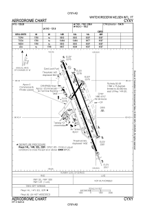


CYXY - Whitehorse/Erik Nielsen Intl
Located in Whitehorse, Canada
ICAO - CYXY, IATA - YXY
Data provided by AirmateGeneral information
Coordinates: N60°42'34" W135°4'2"
Elevation is 2317 feet MSL.
Magnetic variation is 25° East View others Airports in Yukon Territory
Operational data
Special qualification required
Current time UTC:
Current local time:
Weather
METAR: CYXY 290010Z VRB08KT 40SM -SHRA BKN075TCU BKN120 BKN250 11/M02 A2962 RMK TCU6AC1CI1 AC TR SLP058 DENSITY ALT 2800FT
Communications frequencies: [VIEW]
Runways:
| RWY identifier | QFU | Length (ft) | Width (ft) | Surface | LDA (ft) |
| 14L | 159° | 6597 | 100 | ASPH | 6597 |
| 32R | 339° | 6597 | 100 | ASPH | 6597 |
| 02 | 34° | 1798 | 75 | ASPH | |
| 20 | 214° | 1798 | 75 | ASPH | 1798 |
| 14R | 159° | 9500 | 150 | ASPH | 8657 |
| 32L | 339° | 9500 | 150 | ASPH | 8098 |
| 01 | 9° | 1798 | 75 | ASPH | |
| 19 | 189° | 1798 | 75 | ASPH | |
| 13L | 134° | 4018 | 80 | ASPH | |
| 31R | 314° | 4018 | 80 | ASPH | |
| 13R | 134° | 9500 | 150 | ASPH | |
| 31L | 314° | 9500 | 150 | ASPH |
Airport contact information
Address: Whitehorse Canada
