


CYRS - Red Sucker Lake
Located in , Canada
ICAO - CYRS, IATA - YRS
Data provided by AirmateGeneral information
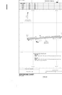
Coordinates: N54°10'3" W93°33'27"
Elevation is 745 feet MSL.
Magnetic variation is -1.05° East View others Airports in Manitoba
Operational data
Special qualification required
Current time UTC:
Current local time:
Weather at : CYIV - Island Lake ( 79 km )
METAR: CYIV 191000Z AUTO 07002KT 8SM OVC016 08/08 A2942 RMK SLP972
TAF: TAF CYIV 190640Z 1907/1919 VRB03KT P6SM SCT005 BKN015 OVC030 TEMPO 1907/1914 2SM -RA BR OVC005 FM191400 30010KT P6SM -RA FEW008 BKN015 OVC030 TEMPO 1914/1919 3SM -RA BR OVC008 RMK FCST BASED ON AUTO OBS. NXT FCST BY 191300Z
Communications frequencies: [VIEW]
Runways:
| RWY identifier | QFU | Length (ft) | Width (ft) | Surface | LDA (ft) |
| 09 | 86° | 3555 | 98 | GRAVE | 3555 |
| 27 | 266° | 3555 | 98 | GRAVE | 3555 |
Airport contact information
Address: Canada