


CYHY - Merlyn Carter Airport
Located in Hay River, Canada
ICAO - CYHY, IATA - YHY
Data provided by AirmateGeneral information
Coordinates: N60°50'23" W115°46'58"
Elevation is 541 feet MSL.
Magnetic variation is 16.0756° East View others Airports in Northwest Territories
Operational data
Special qualification required
Current time UTC:
Current local time:
Weather
METAR: CYHY 271000Z 07010KT 15SM FEW064 BKN077 BKN120 M05/M12 A3006 RMK SC1AC5AC1 SLP193
TAF: TAF CYHY 270540Z 2706/2718 08008KT P6SM SCT040 BKN080 TEMPO 2706/2709 5SM -SN BKN040 FM270900 08010KT P6SM -SN SCT020 OVC040 TEMPO 2709/2713 3SM -SHSN OVC020 FM271300 08010KT P6SM -SN SCT020 OVC040 TEMPO 2713/2718 2SM -SHSN BKN020 RMK NXT FCST BY 271200Z
Communications frequencies: [VIEW]
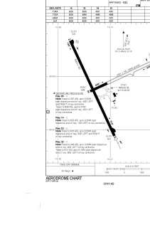
Runways:
| RWY identifier | QFU | Length (ft) | Width (ft) | Surface | LDA (ft) |
| 05 | 65° | 4001 | 150 | GRAVE | 4001 |
| 23 | 245° | 4001 | 150 | GRAVE | 4001 |
| 14 | 155° | 6000 | 150 | ASPH | 6000 |
| 32 | 335° | 6000 | 150 | ASPH | 6000 |
Airport contact information
Address: Hay River Canada