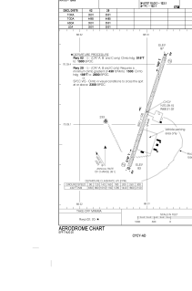


CYCY - Clyde River
Located in , Canada
ICAO - CYCY, IATA - YCY
Data provided by AirmateGeneral information
Coordinates: N70°29'9" W68°31'1"
Elevation is 87 feet MSL.
Magnetic variation is -33.6868° East View others Airports in Nunavut
Operational data
Special qualification required
Current time UTC:
Current local time:
Weather
METAR: CYCY 010600Z AUTO 30003KT 9SM OVC041 M15/M18 A3061 RMK SLP370
TAF: TAF CYCY 010040Z 0101/0113 VRB03KT P6SM FEW015 FEW040 SCT180 FM010300 30005KT P6SM FEW040 SCT080 TEMPO 0103/0109 P6SM -SN SCT040 BKN080 FM010900 30008KT P6SM FEW040 FEW100 RMK FCST BASED ON AUTO OBS. NXT FCST BY 010700Z
Communications frequencies: [VIEW]
Runways:
| RWY identifier | QFU | Length (ft) | Width (ft) | Surface | LDA (ft) |
| 02 | 18° | 3501 | 100 | GRAVE | 3501 |
| 20 | 198° | 3501 | 100 | GRAVE | 3501 |
Airport contact information
Address: Canada