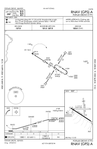


C77 - Poplar Grove
Located in Poplar Grove, United States
ICAO - C77, IATA -
Data provided by AirmateGeneral information
Coordinates: N42°19'22" W88°50'11"
Elevation is 857 feet MSL.
Magnetic variation is -03° East View others Airports in Illinois
Operational data
Special qualification required
Current time UTC:
Current local time:
Weather at : KRFD - Chicago/Rockford Intl ( 26 km )
TAF: KRFD 212055Z 2121/2218 19025G35KT P6SM SCT050 BKN150 TEMPO 2201/2203 25025G50KT 1SM +TSRA SQ BKN030CB FM220300 23025G35KT P6SM BKN025 FM220800 24018G28KT P6SM BKN025 FM221200 26014G24KT P6SM BKN025
Communications frequencies: [VIEW]
Runways:
| RWY identifier | QFU | Length (ft) | Width (ft) | Surface | LDA (ft) |
| 09 | 90° | 2709 | 200 | GRASS | |
| 27 | 270° | 2709 | 200 | GRASS | |
| 12 | 123° | 3773 | 50 | ASPH | |
| 30 | 303° | 3773 | 50 | ASPH | |
| 17 | 176° | 2467 | 150 | GRASS | |
| 35 | 356° | 2467 | 150 | GRASS |
Airport contact information
Address: Poplar Grove United States
