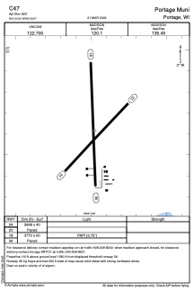


C47 - Portage Muni
Located in Portage, United States
ICAO - C47, IATA -
Data provided by AirmateGeneral information
Coordinates: N43°33'37" W89°28'58"
Elevation is 825 feet MSL.
Magnetic variation is -03° East View others Airports in Wisconsin
Operational data
Special qualification required
Current time UTC:
Current local time:
Weather at : KDLL - Baraboo/Wisconsin Dells Rgnl ( 24 km )
METAR: KDLL 161635Z AUTO 19009KT 10SM SCT022 BKN030 OVC038 18/13 A2978 RMK AO2 T01790127
Communications frequencies: [VIEW]
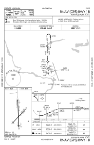
Runways:
| RWY identifier | QFU | Length (ft) | Width (ft) | Surface | LDA (ft) |
| 04 | 43° | 2668 | 40 | ASPH | |
| 22 | 223° | 2668 | 40 | ASPH | |
| 18 | 178° | 3770 | 60 | ASPH | |
| 36 | 358° | 3770 | 60 | ASPH |
Airport contact information
Address: Portage United States