


C00 - Mercer County
Located in Aledo, United States
ICAO - C00, IATA -
Data provided by AirmateGeneral information
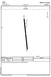
Coordinates: N41°14'55" W90°44'14"
Elevation is 740 feet MSL.
Magnetic variation is 02° East View others Airports in Illinois
Operational data
Special qualification required
Current time UTC:
Current local time:
Weather at : KMLI - Quad Cities Intl ( 29 km )
METAR: KMLI 220152Z 20013G26KT 10SM BKN055 28/18 A2947 RMK AO2 PK WND 20028/0141 SLP973 T02780183
TAF: KMLI 220144Z 2202/2224 20019G26KT P6SM SCT030 BKN050 FM220500 26015G22KT P6SM BKN030 FM221200 26011KT P6SM SCT200 FM221800 28013G21KT P6SM BKN100
Communications frequencies: [VIEW]
Runways:
| RWY identifier | QFU | Length (ft) | Width (ft) | Surface | LDA (ft) |
| 17 | 0° | 2480 | 45 | ASPH | |
| 35 | 0° | 2480 | 45 | ASPH |
Airport contact information
Address: Aledo United States