


9D9 - Hastings
Located in Hastings, United States
ICAO - 9D9, IATA -
Data provided by AirmateGeneral information
Coordinates: N42°39'48" W85°20'45"
Elevation is 800 feet MSL.
Magnetic variation is -06° East View others Airports in Michigan
Operational data
Special qualification required
Current time UTC:
Current local time:
Weather at : KGRR - Gerald R Ford Intl ( 28 km )
METAR: KGRR 171553Z 09003KT 8SM BKN019 21/17 A2981 RMK AO2 SLP090 T02110172 $
TAF: KGRR 171320Z 1713/1812 24007KT 5SM BR BKN007 FM171500 24006KT P6SM BKN015 FM171700 25008KT P6SM SCT250 FM180600 00000KT 2SM BR SKC
Communications frequencies: [VIEW]
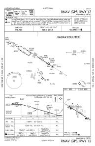
Runways:
| RWY identifier | QFU | Length (ft) | Width (ft) | Surface | LDA (ft) |
| 09 | 87° | 2380 | 170 | GRASS | |
| 27 | 267° | 2380 | 170 | GRASS | |
| 12 | 122° | 5003 | 75 | ASPH | |
| 30 | 302° | 5003 | 75 | ASPH | |
| 18 | 179° | 1952 | 200 | GRASS | |
| 36 | 359° | 1952 | 200 | GRASS |
Airport contact information
Address: Hastings United States