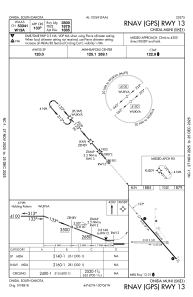
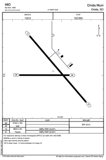


98D - Onida Muni
Located in Onida, United States
ICAO - 98D, IATA -
Data provided by AirmateGeneral information
Coordinates: N44°42'2" W100°6'5"
Elevation is 1885 feet MSL.
Magnetic variation is 06° East View others Airports in South Dakota
Operational data
Special qualification required
Current time UTC:
Current local time:
Weather at : KPIR - Pierre Rgnl ( 38 km )
METAR: KPIR 210053Z AUTO 32007KT 10SM OVC070 12/10 A2990 RMK AO2 RAB12E29 SLP127 P0000 T01220100
TAF: KPIR 202334Z 2100/2124 36011KT P6SM VCSH BKN080 FM210900 02010G16KT 6SM -SHRA BR OVC030 FM211100 02011G18KT 6SM -SHRA BR OVC019 FM211600 36019G26KT 4SM -SHRA BR OVC015 FM211800 35021G28KT 5SM -SHRA BR OVC021 FM212000 34021G29KT P6SM BKN035
Communications frequencies: [VIEW]
Runways:
| RWY identifier | QFU | Length (ft) | Width (ft) | Surface | LDA (ft) |
| 08 | 91° | 2160 | 120 | GRASS | |
| 26 | 271° | 2160 | 120 | GRASS | |
| 13 | 139° | 3800 | 60 | ASPH | |
| 31 | 319° | 3800 | 60 | ASPH |
Airport contact information
Address: Onida United States