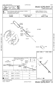
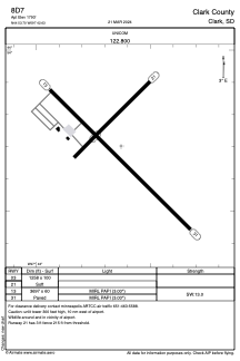


8D7 - Clark County
Located in Clark, United States
ICAO - 8D7, IATA -
Data provided by AirmateGeneral information
Coordinates: N44°53'42" W97°42'38"
Elevation is 1793 feet MSL.
Magnetic variation is 04° East View others Airports in South Dakota
Operational data
Special qualification required
Current time UTC:
Current local time:
Weather at : KATY - Watertown Rgnl ( 44 km )
METAR: KATY 210053Z AUTO 05004KT 10SM -RA BKN100 16/12 A2985 RMK AO2 RAB2354 SLP108 P0000 T01560122
TAF: KATY 202334Z 2100/2124 02007KT P6SM VCSH OVC100 FM210900 03012G19KT 6SM SHRA BR OVC030 FM211300 03017G25KT 2SM SHRA BR OVC007 FM211800 02025G34KT 1 1/2SM SHRA BR OVC006 FM212000 01026G37KT 2SM SHRA BR OVC008 FM212200 36031G40KT P6SM OVC010
Communications frequencies: [VIEW]
Runways:
| RWY identifier | QFU | Length (ft) | Width (ft) | Surface | LDA (ft) |
| 03 | 45° | 1258 | 100 | GRASS | |
| 21 | 225° | 1258 | 100 | GRASS | |
| 13 | 135° | 3697 | 60 | ASPH | |
| 31 | 315° | 3697 | 60 | ASPH |
Airport contact information
Address: Clark United States