


89CA - Halter Ranch
Located in Paso Robles, United States
ICAO - 89CA, IATA -
Data provided by AirmateGeneral information
Coordinates: N35°38'40" W120°51'1"
Elevation is 1488 feet MSL.
Magnetic variation is 15° East View others Airports in California
Operational data
Special qualification required
Current time UTC:
Current local time:
Weather at : KPRB - Paso Robles Muni ( 20 km )
METAR: KPRB 211441Z AUTO 00000KT 2SM BR OVC002 08/08 A2999 RMK AO2 VIS 1 1/2V3 T00830078
TAF: KPRB 211254Z 2113/2212 VRB03KT 1/2SM FG VV002 FM211500 VRB03KT 5SM BR BKN007 FM211700 VRB03KT P6SM SKC FM212000 30006KT P6SM SKC FM212300 21009KT P6SM SKC FM220300 30008KT P6SM SKC
Communications frequencies: [VIEW]
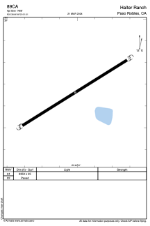
Runways:
| RWY identifier | QFU | Length (ft) | Width (ft) | Surface | LDA (ft) |
| 04 | 0° | 3353 | 25 | ASPH | |
| 22 | 0° | 3353 | 25 | ASPH |
Airport contact information
Address: Paso Robles United States