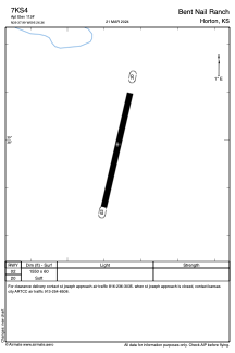


7KS4 - Bent Nail Ranch
Located in Horton, United States
ICAO - 7KS4, IATA -
Data provided by AirmateGeneral information
Coordinates: N39°37'59" W95°26'22"
Elevation is 1124 feet MSL.
Magnetic variation is 05° East View others Airports in Kansas
Operational data
Special qualification required
Current time UTC:
Current local time:
Weather at : KSTJ - Rosecrans Meml ( 48 km )
METAR: KSTJ 210453Z AUTO 13012KT 10SM BKN050 BKN070 BKN090 25/18 A2973 RMK AO2 SLP057 T02500183
TAF: KSTJ 210520Z 2106/2206 13012KT P6SM BKN050 BKN070 BKN090 FM211300 18015G25KT P6SM SCT050 FM212000 20020G33KT P6SM VCTS BKN050CB FM220000 25011KT P6SM SKC
Communications frequencies: [VIEW]
Runways:
| RWY identifier | QFU | Length (ft) | Width (ft) | Surface | LDA (ft) |
| 02 | 0° | 1550 | 60 | GRASS | |
| 20 | 0° | 1550 | 60 | GRASS |
Airport contact information
Address: Horton United States