


7B9 - Ellington
Located in Ellington, United States
ICAO - 7B9, IATA -
Data provided by AirmateGeneral information
Coordinates: N41°55'32" W72°27'26"
Elevation is 253 feet MSL.
Magnetic variation is -15° East View others Airports in Connecticut
Operational data
Special qualification required
Current time UTC:
Current local time:
Weather at : KBDL - Bradley Intl ( 19 km )
METAR: KBDL 040251Z 15008KT 10SM FEW140 SCT230 13/07 A3024 RMK AO2 SLP239 T01330072 51020
TAF: KBDL 032320Z 0400/0506 13007KT P6SM SCT250 FM040500 18005KT P6SM SCT250 FM040900 00000KT P6SM SCT150 FM041200 05004KT P6SM SCT060 FM041800 11006KT P6SM BKN060 FM050200 12008KT P6SM BKN015
Communications frequencies: [VIEW]
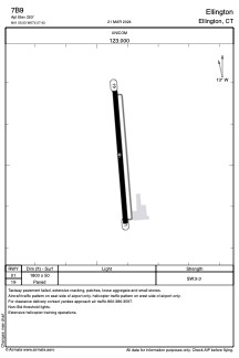
Runways:
| RWY identifier | QFU | Length (ft) | Width (ft) | Surface | LDA (ft) |
| 01 | 355° | 1800 | 50 | ASPH | |
| 19 | 175° | 1800 | 50 | ASPH |
Airport contact information
Address: Ellington United States
Other aviation service providers
Flight schools

Northeast Helicopters Flight Services, Llc
Northeast Helicopters Flight Services, Llc
john@northeasthelicopters.com8608712054