


7B3 - Hampton Airfield
Located in Hampton, United States
ICAO - 7B3, IATA -
Data provided by AirmateGeneral information
Coordinates: N42°57'41" W70°49'49"
Elevation is 93 feet MSL.
Magnetic variation is -16° East View others Airports in New Hampshire
Operational data
Special qualification required
Current time UTC:
Current local time:
Weather at : KPSM - Portsmouth Intl At Pease ( 13 km )
TAF: KPSM 202325Z 2100/2124 07009KT P6SM BKN250 FM210300 VRB03KT P6SM SCT030 FM210600 VRB03KT 1SM BR OVC005 FM211100 VRB03KT 4SM BR OVC005 FM211300 17008KT P6SM BKN250
Communications frequencies: [VIEW]
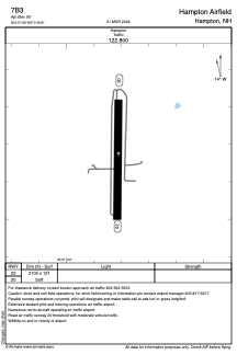
Runways:
| RWY identifier | QFU | Length (ft) | Width (ft) | Surface | LDA (ft) |
| 02 | 1° | 2105 | 121 | OTHER | |
| 20 | 181° | 2105 | 121 | OTHER |
Airport contact information
Address: Hampton United States
