


78OH - Valley City Flying Club
Located in Valley City, United States
ICAO - 78OH, IATA -
Data provided by AirmateGeneral information
Coordinates: N41°15'27" W81°58'9"
Elevation is 867 feet MSL.
Magnetic variation is -06° East View others Airports in Ohio
Operational data
Special qualification required
Current time UTC:
Current local time:
Weather at : KCLE - Cleveland-Hopkins Intl ( 19 km )
METAR: KCLE 220451Z 19010KT 10SM CLR 25/14 A2982 RMK AO2 SLP105 T02500144 403220211
TAF: KCLE 220340Z 2204/2306 18011KT P6SM FEW250 FM221400 21013G21KT 6SM -SHRA VCTS BKN050CB FM221800 23013G21KT P6SM BKN060 TEMPO 2218/2221 4SM -TSRA OVC040CB FM222200 24010KT P6SM OVC060
Communications frequencies: [VIEW]
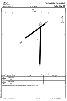
Runways:
| RWY identifier | QFU | Length (ft) | Width (ft) | Surface | LDA (ft) |
| 05 | 53° | 1800 | 50 | GRASS | |
| 23 | 233° | 1800 | 50 | GRASS | |
| 18 | 181° | 2300 | 100 | GRASS | |
| 36 | 1° | 2300 | 100 | GRASS |
Airport contact information
Address: Valley City United States