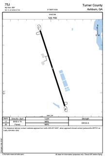


75J - Turner County
Located in Ashburn, United States
ICAO - 75J, IATA -
Data provided by AirmateGeneral information
Coordinates: N31°41'15" W83°37'59"
Elevation is 389 feet MSL.
Magnetic variation is -06° East View others Airports in Georgia
Operational data
Special qualification required
Current time UTC:
Current local time:
Weather at : KTMA - Henry Tift Myers ( 32 km )
METAR: KTMA 181015Z AUTO 21005KT 10SM BKN028 BKN040 OVC049 22/22 A2990 RMK AO2 LTG DSNT N AND S AND W CIG 026V031 T02220221
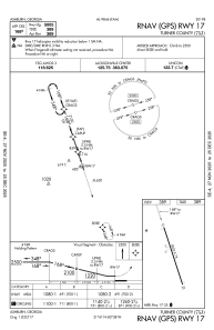
Communications frequencies: [VIEW]
Runways:
| RWY identifier | QFU | Length (ft) | Width (ft) | Surface | LDA (ft) |
| 17 | 0° | 5005 | 75 | ASPH | |
| 35 | 0° | 5005 | 75 | ASPH |
Airport contact information
Address: Ashburn United States