


74S - Anacortes
Located in Anacortes, United States
ICAO - 74S, IATA -
Data provided by AirmateGeneral information
Coordinates: N48°29'55" W122°39'45"
Elevation is 246 feet MSL.
Magnetic variation is 21° East View others Airports in Washington
Operational data
Special qualification required
Current time UTC:
Current local time:
Weather at : KNUW - Whidbey Island Nas (Ault Fld) ( 16 km )
METAR: KNUW 211553Z 13014KT 5SM RA BR SCT015 BKN035 OVC050 09/08 A3006 RMK AO2 SLP184 P0005 T00940083 $
TAF: TAF KNUW 2107/2207 24012G20KT 9999 SCT070 BKN150 QNH3011INS FM211200 17010KT 8000 -RA BR BKN012 OVC020 650607 QNH3008INS BECMG 2114/2116 15013G18KT 6000 RA BR BKN005 OVC010 650605 540009 540909 QNH2982INS TEMPO 2120/2200 16018G28KT FEW003 OVC010 BECMG 2201/2203 17010G16KT 9000 -RA BKN003 OVC010 650604 500000 QNH2975INS FM220600 25010KT 9999 -RA BKN015 OVC020 650602 QNH2974INS TX16/2123Z TN10/2112Z FS30224
Communications frequencies: [VIEW]
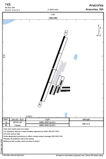
Runways:
| RWY identifier | QFU | Length (ft) | Width (ft) | Surface | LDA (ft) |
| 18 | 200° | 3018 | 60 | ASPH | |
| 36 | 20° | 3018 | 60 | ASPH |
Airport contact information
Address: Anacortes United States