


71K - Westport
Located in Wichita, United States
ICAO - 71K, IATA -
Data provided by AirmateGeneral information
Coordinates: N37°38'52" W97°23'1"
Elevation is 1290 feet MSL.
Magnetic variation is 07° East View others Airports in Kansas
Operational data
Special qualification required
Current time UTC:
Current local time:
Weather at : KICT - Wichita Dwight D Eisenhower Ntl ( 4 km )
METAR: KICT 200209Z 07011KT 10SM TS FEW027 BKN060CB BKN075 18/17 A2981 RMK AO2 PK WND 36028/0154 WSHFT 0149 FRQ LTGICCCCG VC NE-E-SE TS VC NE-E-SE MOV E SHRA VC NE-E-SE T01830172 $
TAF: KICT 200134Z 2002/2024 33018G29KT 2SM +TSRA BR SCT018 OVC040CB TEMPO 2002/2003 VRB15G25KT 6SM TSRA BR OVC030CB FM200300 VRB15G25KT 6SM TSRA BR OVC050CB FM200500 11012KT P6SM VCSH SCT040 OVC100 FM201200 13012KT P6SM BKN015 OVC080
Communications frequencies: [VIEW]
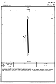
Runways:
| RWY identifier | QFU | Length (ft) | Width (ft) | Surface | LDA (ft) |
| 17 | 0° | 2520 | 30 | ASPH | |
| 35 | 0° | 2520 | 30 | ASPH |
Airport contact information
Address: Wichita United States